

Bass Strait Kayak Crossing Feb 2024
- Paul Monaro
- May 23, 2024
- 28 min read

Updated: Nov 23, 2024

This is a day-by-day, blow-by-blow description of the Bass Strait kayak expedition by Graham Brown, John Hutchinson, Rachel Twomey, and myself.

On 12 February 2024, I joined my three paddling companions at Port Welshpool, to the northeast of Wilsons Promontory, Victoria. Our plan was to launch from there on or soon after 13 February, for our intended Bass Strait crossing. This had been in the planning for over 12 months, and our training had intensified over the previous 3 months to ensure we were ready for some longer distances and consecutive days of paddling.

The forecast for 13 February looked great, with clear weather during most of the day, and a strong northeasterly wind that would help to push us down the coast of Wilsons Promontory to our first destination at Refuge Cove. However, there was a severe storm warning for late in the day, so the consensus decision was that it was not worth the risk,

particularly if the storm was to hit earlier while we were still on the water. So, we delayed our departure until the 14th. This ended up being a good call. The storm didn’t come early, but when it did it was severe, and the subsequent destruction led to blackouts over the entire southern part of Victoria. We were well protected in our cabins at Port Welshpool.
Thanks to Graham for the photos supplied from Port Welshpool.
Crossing Day 1, Wed 14 Feb, Post Welshpool to Refuge Cove: Winds 15-25kn SW; Swell 1-2m W-SW. Distance 43km.
If things went to plan our Bass Strait crossing would involve 9 days on the water and 8 camping locations. The duration of the camping stops would be entirely weather-dependent.
The forecast for launch day was for clear skies, but unfortunately, there was also a moderate south-westerly wind blowing. We prepared to punch into a headwind for at least the first third of our journey, and a possible lively exit from the bay due to strong currents and wind against tide. Some fishos warned us the going would be treacherous.
We departed a little before 8am and had a very energetic paddle out of the bay, and then around the northeast peninsula of Wilsons Promontory. The wind along the coast of the

Promontory averaged 10 to 14 knots and was headwind for most of the day. Added to this, our navigator Graham was having trouble keeping water out of his boat. On regular paddles with his kayak unladen he usually experienced greater than average water ingress, mainly into his cockpit. Here, with it fully laden (weighing up towards 85kg) and sitting low in the water, he spent most of the day with his cockpit more than half full of water. Rachel referred to his boat as the 'yellow submarine'. So, we had a longer-than-anticipated day on the water. We covered 43km in just under 8 hours.
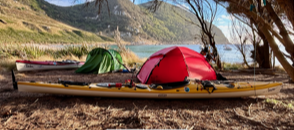
We unloaded our gear on the beach at Refuge Cove and hauled our kayaks up to our campsite so they wouldn’t be washed away overnight. Then we set-up our tents for the first night away from civilisation. We hadn’t left the mainland yet, but our journey was underway, and the first leg completed.


Thanks to Graham for the photos supplied, including of our launch and our campsite at Refuge Cove.
Crossing Day 2, Thursday 15 February: Refuge Cove to Hogan Island. Winds W-SW 5-10kn; swell 1-1.5m SW. Distance 53km.
We set off just before 9am for our first crossing, finally leaving the mainland, and facing the second longest paddle we would encounter. Because it is so distant and a low-lying island, you can’t see Hogan when you set off. I spotted its faint bump about 11km out from Refuge.

The direct line distance from Refuge Cove to Hogan Island is just shy of 50km. But with cross-currents which would shift direction during the day, our distance could have been substantially longer. Fortunately, our navigator Graham (“The Professor” as he came to be known) did an excellent job with his first challenge. Our crossing ended up being 52.5km.

What was greater than expected was the time it took us - close to 9 hours. On departure, we had a forecast of a moderately helpful tailwind. This didn’t eventuate. And the current running against us was stronger than expected. We averaged less than 6km/hour over a day that ended up being a bit of a slog. But Hogan was waiting for us with clear weather and plenty of daylight left to dry ourselves and settle in for our first rest day.
Thanks to Rachel and Graham for the photos provided. In particular, this amazing underwater shot of the dolphins under Rachel's boat was taken by her at the start of our crossing. The fuzzy surface shot of part of a dolphin is my best contribution to the day's photo gallery.


The last few pics show us approaching, then landing on Hogan; our course over the day; and the view from Hogan out to our next destination.
Camping on Hogan Island, Thursday 15 to Saturday 17 February
We had planned to paddle on the Friday, but after our big Thursday paddle the ‘veteran’ Johnny Hutch made the call that a rest day would be a good idea. (John had done the crossing 8 years ago). It ended up being a good call. We not only recharged the batteries, but we also got to spend a day looking around an island that is somewhat maligned. It is known in some circles to be barren and uninteresting. The Hogan Island group is located on the border between Victoria and Tasmania. The vegetation is low-lying scrub. From at least the middle of the last century, it was used for grazing cattle and sheep. This was banned in the last decade due to the damage to the vegetation. Fencing and cattle pens are still


visible.
We walked to the top of the hill (116m above sea level) and were greeted with spectacular
views. The island is home to a species of blue-tongued lizard, of which we saw many (see Rachel's video on the left). And walking along the rocky foreshore was an experience. The water was crystal clear. In the rocks were crevices that were sharp and sometimes deep. I took on the challenge of trying to walk quietly to creep up on the crabs, of similar size to blue swimmers, so I could have a good look at one. I never succeeded. They darted away in a flash and were only ever a brief image in my peripheral vision. I didn’t see any penguins, but they were present, as evidenced by Rachel’s intimate photo.
There is a fisho’s hut on Hogan, and visitors are welcome to use it for cooking and shelter. Even gas, tinned food, and water were available, courtesy of previous visitors who have made donations. As we were the only visitors at that time, we had it all to ourselves. We signed the visitor's book and found past entries from fellow Bass Strait kayakers, some of whom are well-known to us.
We had two nights on Hogan Island, using the hut for most of our meals and camping close by. The weather continued to be kind - clear, sunny, and mild.


Thanks to Rachel for the wildlife, 'pebbles', and some of the other pictures provided, and Graham for the photos inside the hut and of the night sky.
Crossing Day 3 Saturday 17 February: Hogan Island to Deal Island. Distance 46km. Winds W-WNW 5-15kn; Swell 1m


This was to be a moderately long crossing, and wind and current forecasts suggested that an early start was desirable. We were on the water before 6.30 am. This ended up being an engaging crossing, with beam winds from the northwest that gave us reasonable assistance and kept us ‘on our toes’. With the sails up for the entire journey, the cross-wind made it necessary to weight shift and regularly adjust with subtle changes of direction. And a sizable swell for the last couple of hours made it even more exciting.
After a 46km journey, and an average 7.1km hour speed, we arrived at Winter Cove on Deal Island, the jewel in the Bass Strait crown. We negotiated a moderate surf landing without incident and set about preparing our campground for what would be our longest stay on any of the islands.


Thanks to Graham for the stills taken from his GoPro footage.
Deal Island, Saturday 17 February to Thursday 22 February. Part A
Graham had been looking forward to exploring Deal for years since he had heard the glowing tales from some previous expeditioners. It was with smiling satisfaction that he and John informed us that weather forecasts dictated we would be ‘stuck’ on Deal for at least four days. It ended up being the highlight of the trip. The scenery is spectacular, as can be seen from the photos. You could easily spend a week or more looking around Deal and the secondary islands, Erith, and Dover.

Deal is teeming with wildlife, and some creatures are overly intrusive. As soon as we arrived at our campsite, so did the wallabies. They would hop right up and virtually into your lap, and firm discouragement was required to move them on. They eventually got the message, unlike the possums that couldn’t be told no. Some of us took to storing our food in our kayak hatches because they got into everything, including Graham’s tent. They even chewed through sealed silicone bags in search of food. Many of them were overly fat, which was clear evidence that they were regularly fed by visitors. It was a good reminder of why you don’t feed the wildlife.
Deal is the largest in the Kent Group National Park. It has been previously inhabited and home to grazing animals. Historic buildings on the western side of the island are evidence of the small village that once existed there. On the southern end is the old lighthouse. Built in 1848, it is the highest in the southern hemisphere. Its height means that at times it is lost in the clouds and not clearly visible from the sea. Hence, it was deactivated in 1992.
As well as great walks and spectacular scenery we met the caretakers of the island who were soon to finish their 3 months as volunteers. They gave us some of their fresh produce from their veggie garden and filled us in on some of the history and recent happenings on the island.


Thanks, Rachel for the collage, and her and Graham for the wildlife pictures.
Deal Island, Saturday 17 February to Thursday 22 February – Part B
As soon as we arrived at our campsite on the edge of the beach at Winter Cove, John busied himself forming discarded planks and logs into a picnic table and chairs. This came in useful. We had five nights and four full days on Deal Island. Strong winds kept us at bay – even making a local paddle to explore Erith and Dover Islands a difficult assignment. That wasn’t a concern. There was enough of Deal for us to explore on foot from where we were.
It is a vigorous walk up the hill to get to the historic village and to sightsee the other bays and mountains. We did this walk or part of it daily just to collect water. There is a system on the island where the caretakers provide clean drinking water for any visitors, particularly campers. They deliver these by ATV as needed. Two full 20-litre drums were always available


for us.
The four of us walked to the village and some of the main lookouts on our first full day. Then Graham and I did the walk to the lighthouse a few days later. Rachel went exploring every day, covering pretty much the whole island. She took literally hundreds of magnificent photographs so that the rest of us could share in her adventure. If only I could display them

all…
On one of our less energetic days, Graham managed to catch fish for our dinner – a whiting which we shared for entrée, and an Australian salmon which we made into a very nice fish curry. On that same day, a pod of dolphins appeared in the bay, only a couple of hundred metres from our campsite. To his credit, Graham swam out and took some nice photos, including underwater shots that rivalled Rachel’s from a few days earlier.
Mobile phone reception was present on the island, but only in a few select locations. We could walk from our campsite to the other side of the bay to the ‘Telstra Rock’ that had a clear sight of Flinders Island. And, from the historic village, you could walk ten minutes down the hill to the ‘Telstra Chair’ that faced back towards the mainland. Or you could do the long and steep walk to the lighthouse. It was on this day, with reasonably good reception and access to his various apps that the Professor was able to look at the weather and tide/current data for the next day and crunch all the numbers in

his head to formulate our plan. We were readying to depart early the following morning.
Easterly and north-easterly swells had been running for a couple of days. Unfortunately, this can bring a big swell into the beach at Winter Cove. We had the prospect of favourable winds and weather for our big paddle to Roydon Island, but first we had to get off Deal. It could have been my imagination, but the waves crashing all night before we set off seemed


considerably louder than they had the previous nights.


Thanks, Rachel & Graham for many of the great photos in 'Deal Island Part A & B'.


Crossing day 4, Thursday 22 February: Deal Island to Roydon Island. Distance 63km. Wind NNE 10-15knots, and 20knots NE later in the day. Swell 1-1.5m ENE.
For distance, this was to be the big one. As the crow flies Winter Cove to the landing point at Roydon Island is 61km. But currents, winds, poor luck, and miscalculations can make it a 75km+ crossing.
First, we had to deal with a launch through moderate surf, as the ENE swell meant it was coming almost straight into the beach. We timed our charge as best we could, and launched one at a time, the others assisting those ahead. Part of the trick with launching through waves is keeping your kayak pointing straight until you deem the time is right, with no large sets coming in. This was the job of those assisting, as well as to give an encouraging push on take-off. We got Rachel away first in a nice lull. Once she was out the

back of the breakers it was Graham’s turn. He got hit with one moderate wave that turned him sideways, but undaunted he braced, kept his balance, straightened up, and paddled out to safety. I punched out next without too much trouble. John (the veteran) launched last, with the help of the island’s caretakers who had kindly walked down the hill to help us get off the beach safely.


We were anticipating some assistance from the wind. Our course was generally SW to SSW, and we had an NE to NNE wind. The swell was light. Due to the wind, Graham’s navigation, and determined pace setting from Rachel, we made excellent progress. The last couple of hours were particularly enjoyable when we had a beam wind that strengthened to around 20 knots and at times pushed us along at over 10km/hr.
We battled a moderate headwind for the last 30 minutes due to local conditions around Roydon, but all-in-all we arrived feeling we still had some fuel in the tank. And thanks to our navigator, we only had to paddle 63km, an extraordinarily ‘short’ distance considering the cross-currents we had to contend with.


Thanks to Rachel and Graham for their photographic contributions.
Roydon Island Thursday 22 February to Saturday 24 February
Roydon is a small uninhabited island almost within a stone's throw of Flinders Island. It has one tallish rocky bluff but is otherwise fairly flat. Away from the rocky shore it is covered in small trees (a little over head-height) and low prickly shrubs. The attraction with camping on Roydon is there is a large fisherman’s hut (which I named Don’s hut), fresh water, and shelter from the wind.

When we landed, we were immediately set upon by scores of March flies, which could easily bite through even our thicker layers of kayak clothing. The only come-back was they were slow and easy to swat. But their sheer numbers forced us into a quick unload and race up the hill in search of Don’s hut. Fortunately, the flies seemed to congregate around the beach and didn’t follow us to our shelter. We set up our tents around the hut (other than ‘elder statesman’ John who was granted the luxury of the double bed inside) and settled in for a two-night’s stay.
The day after landing was promising 40knot north-westerly winds and large swells, so once again we were forced to relax and treat ourselves to a rest day and exploration of the island. Some of the group went for a swim (a very quick dip for me), with the water temperature in the bay being a climatically concerning 21 degrees/C.


The nights were interesting. The island is home to many penguins, and they make a racket, generally from around the time you're starting to drift off to sleep. Their crying sounds almost like human babies. You couldn’t get annoyed though because they are such cute little critters. The one in the photo spent a lot of time wailing just outside my tent.


Most photos courtesy Graham
Roydon Island Friday 23 February, lay day.
Our day off dawned clear but with gale-force winds blowing from the northwest. I was up in time to see the sun rising over Flinders Island and reflecting in the bay that was somewhat protected from the wind.
Graham and I decided on a circumnavigation of the island, a not-too-daunting prospect as it would be likely to take less than a couple of hours. However, I don’t know what I was thinking when I set off in a pair of thongs. And Graham was soon rueing not wearing long pants. We had to walk through many shrubs that were sharp and prickly. And the rocky terrain was rough and uneven. We had to take a slow and cautious approach but made it without any mishaps.


We took some video footage of the lively sea. There were a few interesting features on the island which we also photographed. John had set off behind us – in trousers and enclosed shoes – and caught up when we were rounding the last headland back towards the bay and
beach below Don’s hut.
Then it was a leisurely afternoon back at the hut and out of the wind. As she often did, Rachel set off on her own adventure, which included exploring the whole island and climbing to the top of the bluff. No doubt she would have welcomed having her abseiling equipment to make it a worthwhile challenge, but she had to settle for what the island could provide.


All these amazing photos courtesy Rachel
My Audax that I used for the trip is one of the kayak models designed and built by Rob Mercer in NSW. As well as being probably the best all-round expedition kayak in the world, it has amazing storage capacity. As far as we know, no one has previously taken a guitar with them on a Bass Strait kayak expedition. But, along with around 60kg of gear, food, and water stored in the generous compartments, the rear hatch was able to accommodate my Martin travel guitar, and it stood up to the journey with no problems. It came out of its bag most nights, with Rachel and me taking it in turns to bang out a few tunes. And it was the perfect companion for afternoons like this. Nothing on the agenda, sitting in the sun, no time constraints, no interruptions. This is what it’s all about. And plenty of time to compose a little ditty called ‘Don’s Hut’.


Thanks to Rachel and Graham for most of the photos provided.
Crossing day 5, Roydon Island to Whitemark on Flinders Island. 37.76km, winds 5knots N-NNW; swell bugger-all.


In mild conditions, the shelter provided by the islands to the west of Flinders Island make this leg of the journey a gentle and relaxing one, as it was for us. Being close to shore, and in no hurry, we pulled into Wybalenna, part way down the coast, for morning tea and a lie down in the sun.
North of our landing point are the Wybalenna Chapel and cemetery. This area represents a significant chapter in indigenous and early European history. From the early 1800's, conflicts

between European settlers and Aboriginals on the Tasmanian mainland threatened the existence of the original inhabitants. By 1828, the indigenous population in Tasmania was estimated to have been reduced from around 6000 (and possibly as many as 15,000) to under 1000. From that time martial law was declared, and it became legal to shoot aboriginal people who were found in the vicinity of white settlements and farms. A bounty of 5 pounds was placed on the head of any indigenous adult, and 2 pounds for the capture of any child.
Governor Arthur and George Augustus Robinson (colonial official and preacher) came up with the plan to exile indigenous Tasmanians to some of the nearby islands to help ensure their survival. Some Aboriginals were convinced to move to settlements on Swan Island, Gun Carriage Island, and The Lagoons, near Whitemark. Later, this included Wybalenna, which opened in 1833 and became the biggest settlement. The word Wybalenna means "black man's houses". However, between 1834 and 1847, 150 of 200 indigenous exiles died from combinations of European diseases, poor nutrition and shelter, and complications related to homesickness and the trauma of dislocation from their land. Wybalenna was closed in 1847. Many of their children having been forcibly removed, the remaining Aboriginals were moved to Oyster Bay, back on the Tasmanian mainland, where the rest of them eventually died.
It is thought that 100 or more bodies of indigenous exiles are buried in the region near where Wybalenna Cemetery is today. However, unlike the European graves, where each site is marked with a grand individual headstone, a single plaque was erected in remembrance of the indigenous victims. It reads "Erected by the junior farmers of Flinders Island to commemorate approximately 100 Tasmanian Aboriginals buried in this vicinity of Wybalenna 1833-1847". [Sources for the above information: https://www.flinders.tas.gov.au/aboriginal-history; https://www.roamingdownunder.com/wybalenna.php; SBS On Demand First Australians, episode 2].
After Wybalenna, It was an easy paddle to Whitemark, the ‘capital’ of Flinders Island. We had two nights


at Whitemark. This time it wasn’t weather dictated. It was because of the presence of a pub with tap beer and hot meals. There was also a general store to restock some of our supplies. We set up camp close to the beach in a location we hoped was out of the way, so we didn’t upset the locals. (We only heard one complaint). From there it was a

short walk to the centre of town.
There is a gin distillery overlooking the water with a swanky restaurant. We tried to get in, but they were booked out. We were told the pub was our only option for dinner, but even this was looking sketchy when we arrived. The whole town had a black-out (other than the distillery which had a generator – hence the full restaurant). Some oldish local had fallen off his roof, decided he wasn’t too critical, and attempted to drive himself to a doctor. He blacked out on the way and ran into an electrical pole. (We hope he is ok). Fortunately, the beer taps work on pressure, not power, so we had a few half-pints while waiting for updates on the blackout. The local electricity workers had already been going hard at it for a few hours and the power was soon restored. We were assured the kitchen would open on time.
After refreshing we returned for dinner and a few more ales. John and I chose the wallaby salad, which ended up being the culinary highlight of the trip. The meat was served medium-rare and was as tender as an eye fillet. And tastier. It wasn’t the least bit gamey like kangaroo meat. Unfortunately, it isn’t available outside of the southern states, but I’m thinking of lobbying my local member to see if I can rectify this.


There was a very nice café in town for our two breakfasts, and our meal on the second night

was at the golf club. Not bad, but it was no wallaby salad!
From our campsite, we got to enjoy rare western sunsets.
Crossing day 6, Whitemark to Trousers Point, 13km, wind 5-10kn N-NNW, swell 1.5m east. Last 30 minutes of paddle 25kn+ headwind (ESE).


We were anticipating a short and uneventful coastal trip to our next campsite on the southwestern corner of Flinders Island. We set off early enough to do the paddle, set up camp, and attempt the strenuous walk to and from and to the peak of Mt Strzelecki. But Murphy decided to step in for our last half-hour of the paddle, and we had 25 knot+ headwinds that weren’t part of the forecast. It was one of those experiences where you had to keep checking the rock formations on the shore to reassure yourself you were making forward progress. We eventually turned out of the wind, landed at Trousers Point beach, unpacked, and prepared for our hike.


Between us, we took many spectacular photos on ascent and at the top of Strzelecki.
Mount Strzelecki, at 756m above sea level, is the tallest mountain on Flinders Island. It was named after a famous Polish explorer who scaled it in 1842. The mountain started to form around 400 to 300 million years ago and later made up part of a large granite belt that linked Wilsons Promontory to Tasmania. Along with many features on the east-coast, including the Great Dividing Range, its formation was mainly completed around 45 million years ago. The breaking free of Antartica and the Australian mainland from Tasmania created tension in the earth's crust that formed many of the mountains and valleys. These were later shaped by ice and water.
The land bridge between Tasmania and mainland Australia was present as recently as 2 million years ago. When the seas rose, they only partly covered this land bridge, leaving numerous islands, some with medium to tall peaks. And, the seabed in Bass Strait is relatively shallow, with an average depth of 60m. (The average depth of the Pacific Ocean is 4000m). The shallow seabed in Bass Strait is the reason for the complex and highly variable currents that exist there. And why large, steep, and breaking waves can often form in areas where you are nowhere near land.


The walk from the campsite at Trousers Point to the base of Strzelecki is 4km. We got there with about five hours of daylight to spare. Rachel led the way, bouncing from path to rock like a mountain goat, and we did our best to follow. We were soon struggling to keep up.
It is 2.8km each way, but as a grade 4 track, it is listed as a 4–5-hour return trip. We did it in 3, with Rachel leaving us well behind on the way down. The three old blokes were happy to admit it was a pretty brutal climb, physically demanding in ways quite different to our days on the water.


On a clear day, as the pictures show, the climb is well worth it. But on my next trip to Flinders, I think I’ll spend more time at the pub.
Crossing day 7, Tuesday 27 February: Trousers Point to Cape Barren Island, then to Clark Island. 43km. Wind 15-20kn E-NE. Swell 1m.

For the previous few days, forecasts had remained steady. To make use of the most favorable conditions, it was looking like we would spend a few nights on Cape Barren Island, one or two on Clark, and should arrive at Little Musselroe Bay on Sunday 3 March.
We set off from Trousers Point early. The first part of this journey was one of our most fun of the entire trip. We were expecting to paddle around 20km to our campsite on the southwestern side of Cape Barren Island. We had strong tailwinds to make our crossing engaging and light work.


Photos Graham
We stopped for lunch at The Corner, the indigenous township on Cape Barren Island*. We did this to ask for permission to camp, and while we were there to see what their shop had on offer for lunch. It was pies and sausage rolls and we cleaned them out.
*History: At the time of the ice age, between 35,000 to around 20,000 years ago, a land bridge between the mainland and Tasmania allowed Aboriginals to settle in Tasmania. There is evidence of human habitation on Flinders Island from 35,000 years ago. When the climate warmed and seas rose some 15,000 to 10,000 years ago, Tasmanian Aboriginals were isolated. European 'discovery' of the eastern Bass Strait islands is recorded from 1773 when Tobias Furneaux charted the waters around Flinders. Although he didn't land, this

group of islands was given the name Furneaux Group. Matthew Flinders charted the same waters in the early 1800's, again without landing, so the largest island was named after him by Governor King, the third Governor of NSW.
A shipwreck on what became known as Preservation Island in 1797 led to the discovery of seals in the region. Sealing commenced at Kent Bay on Cape Barren Island in 1798, and this was the first European settlement south of Sydney. By 1803 around 200 sealers were working the Bass Strait islands. Some of these men kidnapped Aboriginal women to take as wives.
After the disastrous attempted relocation of Tasmanian Aboriginals earlier in the century, the island's indigenous community petitioned the Governor in 1878 to reserve Flinders Island for them. The result was they were granted 4000 acres on Cape Barren Island in 1881. However, in 1951 the Tasmanian government closed Cape Barren Island Aboriginal Reserve, and many inhabitants were forced to move. In 1977 the community petitioned for land rights. In 1981 they were granted 0.6 hectares on Cape Barren Island. In 1995 several cultural sites within the Furneaux Group were returned to the Aboriginal community, and Wybalenna was claimed in 1996. Finally, in 2005, ownership of Cape Barren and Clark Islands was officially handed over to them. Today over 16% of the Furneaux region population is of Tasmanian Aboriginal descent. Source includes: https://www.flinders.tas.gov.au/aboriginal-history;
Alteration to the day's plans. After lunch, our weather experts decided to recheck forecasts for the next few days. It was lucky they did because the original forecast had now been flipped on its head. All hell was ready to break loose in a couple of days.
We were faced with two choices: stick with the original plan and likely be stuck on one of these islands for a week, or cut loose and complete the remainder of the journey by the next afternoon.
It was a disappointment, but a sensible decision to cut the great adventure short and head for the finish line. Our paddle that day was suddenly twice as long, and our stop on the magnificent Cape Barren Island, which looks like it would have been a spectacular place to explore, was suddenly over.
Luckily, we had nice tailwinds for the first part of our trip to Clark Island. The last hour was a bit of a slog, but we arrived at Spike Cove on Clark Island with enough daylight to set-up camp and discuss our plans for the next day.


Thanks, Graham & Rachel, for the photos provided
Crossing day 8, Wednesday 28 February: Spike Cove, Clark Island to Little Musselroe Bay. 7am launch. 37.30km, winds 15-20kn ENE, swell 1.5m.

If you talk to veterans of the Bass Strait crossing, they invariably tell you that it’s not the long crossings you need to be most prepared for. For them, the momentous crossing is one of the shorter ones, Banks Strait. For even experienced seafarers, it has a notorious reputation, and some of the tales are epic. If you misjudge the currents, they can whip you sideways at greater than 6knots/hr. And the seas are unpredictable, particularly when you get near Swan Island, where very fast currents and shallow waters create 'overfalls' – areas of very turbulent, unpredictable, and potentially dangerous water.
Our trip to date had its challenges but nothing unexpected. Looking at the forecast and the currents we would encounter across Banks Strait, we were confident that we would complete this crossing without too much trouble. It pays to listen to the experts.
We launched early, at a time that should have made use of favourable or negligible currents and strong tailwinds. And we made fantastic early progress. The wind was strong and created a sizable sea that pushed us along beautifully. Rachel took great pride in telling us she was sailing along at 10km/hr without using her paddle.


Before long, you could sense that our advantage was weakening and were settling into a grind rather than a breeze downwind. I’ve gotten to know Graham well over the years, and I could tell from his body language that he wasn’t happy about something. I paddled over to ask the Professor how he thought we were doing, and he said our speed was concerningly slow over the past twenty minutes. I asked him if he thought we should try to pick up the pace a bit and he agreed we could give it a try.
When I paddled up to the others to encourage them that we needed to dig in a bit more, I could sense that Rachel was a bit taken aback. With a hint of annoyance, she said “I thought I was going pretty good, but ok, if that’s what you want.” Well, I certainly did ask for it! After about a half-hour of serious effort, I made it across to John and said, “I think I should have left well enough alone there!” He concurred. So, I caught up to Rachel and said, “Well done. I think we can back it off a bit now…”

With the extra pace combined with regular checking of his navigation data, Graham had started to fall a bit behind. When he caught up, he confided that something wasn’t right. Our extra effort had barely helped, and now our progress was slowing further. Things weren’t going to plan.
Unfortunately, the damage had been done before we even launched. For a few complex reasons, and with the idiosyncrasies of Bass Strait, today our navigation plan wasn’t accurate. If we had launched an hour earlier, it would have been completely different. Possibly even the paddle we had been hoping for. But we had got this wrong. The tide had already turned, and it was only going to gain strength from here on.
Before long, our progress had slowed to between 2 to 4km/hr, and the swell went from the forecasted 1.5m to something a lot bigger. At one point I looked south and noticed that Graham’s course had diverged a fair way from ours. I suggested to Rachel and John that they maintain their course while I went to join Graham. But as the seas continued to get bigger, it wasn’t long before Graham and I had difficulty spotting the other two, with their sails only occasionally appearing above the swell. Added to that, it was clear we had entered the zone of the overfalls. The swell kept growing and the wave directions weren’t conforming to any pattern I was used to seeing.


The course we had been following had us essentially aiming for the lighthouse on the northeastern end of Swan Island. We were making slow but definite progress towards this. At one point, around the time we had completely lost sight of the other two, Graham opted for a quick raft-up to check his data for our exact location. And I radioed Rachel to check they were still ok. But by the time we separated and turned back towards the east, the lighthouse had shrunk alarmingly in size. We were both startled! It turned out the current had pushed us close to a kilometre westward in the few minutes we had stopped paddling. You can see this deviation (that came to be known as “the wiggle”) on our GPS trace. So, we dug-in and paddled hard again, this time making even slower progress.
Discussing this later with John and Rachel, they had been caught in an hour-long monumental battle where they were paddling furiously and seemingly going nowhere. Fortunately, they did edge closer to the northeast of the island, and we converged with them about 40 minutes after radio contact. By this time our progress had slowed to a snail’s pace.
For the next 30 minutes, I noticed the oblique shape of the windows on the lighthouse wasn't changing. We were paddling flat-out and going nowhere. This was when we had our first experience of a ‘tiderace’. We were surfing large standing waves and staying in the same place. It could be good fun in the right circumstances, but that wasn’t today. I said to Graham that as this course wasn’t working, maybe we should head more across than into the current. We had avoided this option up to now because of the risk. It meant we would be heading deeper into the overfalls and towards a reef on the edge of the island. But in these circumstances, we had to give it a try. After a few minutes of this new course, Graham was able to reassure me that we were finally making some progress. With added incentive, we dug in and kept paddling hard.


I was somewhat in front of Graham, with Rachel and John further back. With everything else that was going on, amongst the maelstrom, the heaving and churning water, and the completely wild and unfamiliar territory we were in, it seemed almost appropriate what happened next. Just off to my left, within the breakers and almost as tall, up popped a huge black dorsal fin. It was soon gone again, but the next moment a sharp line cut the water right next to me. I reckoned this creature had made a quick diversion to check out what I was. Hmm. Not thrilling. But that’s the ocean for you, so I tried to ignore it and kept my course. About ten seconds later the expletives started. Graham had spotted the same animal, somewhat further away but now with its entire shape visible on the surface of the water. He said the dorsal and tail fins were like sails, and the body was almost as long as his kayak. He had seen many sharks in his time, but nothing like this! He called it ‘megalodon’ and was still talking about it weeks later. There was no questioning the species. The feared queen of the ocean had leapt into the final pages of our story, to remind us of where we were and give our insignificance to this environment some perspective.

Luckily Graham’s shark was the least of our worries. We still had to get out of this current that we later estimated was running at about 9km/hr westward. We had to avoid the reef, and then somehow get back out and around large breaking waves that were appearing further out towards the open water. I was in the lead, zigzagging in and out towards the open sea then back toward land to negotiate both hazards. At one moment I suddenly found myself sideways and had to scoop my paddle across and into the water to regain balance. In that split second, our formidable visitor leapt back into my consciousness once again.
The slog continued for some time but eventually, we made it to a point where we could just about see the other side of Swan Island and the channel we would enter with currents and light wind going in our direction. The burden slowly eased, the water was suddenly calm, and we made it around the southeast of the island where we would be able to make a beeline for Little Musselroe Bay. We still had 8km in front of us, but the hard work was done, and success was assured. It was funny how this was the time when the feeling of acute fatigue finally set in. I tried to have a bit of a whinge to the others, but it seemed to fall on deaf ears.
With the features of the distant and unfamiliar coastline blending into sameness, we needed Graham’s navigation trace to get us home. We settled into a pattern along this line, quietly in formation toward our final destination.


Thanks, Graham for the many images taken from his GoPro footage.
Objective achieved – landing on the Tasmanian mainland.

In the middle of the afternoon, we paddled out of Bass Strait and into the mouth of the river into Little Musselroe. The kayak gods were smiling on us, and the tide was high, meaning

we could paddle right up to our camp spot. We landed, congratulated each other, and set up what would be our last campsite together. Emotions were mixed. A great adventure was suddenly over – somewhat abruptly. But we had experienced something unique, it had been fun, the group dynamic had been excellent, and we had achieved our objective. We were in high spirits, despite the end being somewhat of an anticlimax.

Little Musselroe Bay is a logical place to land after crossing Banks Strait, but apart from a free campsite it has (with no disrespect) very little else to offer. There is no fresh water, no shop, nowhere to buy the bubbly or food, and no pub to blow the froth off a cold one. The nearest town is a 20-minute drive away.


Photos Graham

We had two days sitting in wait for our lift back to Devonport, in a spot where the only point of interest was the windfarm that surrounded us. We would have contemplated paddling on to Bridport, further to the west. But the weather we chose to avoid was about to hit, with 30-knot westerly winds. So, we settled in, chatted, amused ourselves, and made the most of it. We even tolerated the flies early on, until it became apparent they didn’t follow the rules related to insect repellent. Emptying my whole container of Aerogard onto

myself didn’t intimidate them one little bit.
Finally, two days after landing, our lifts arrived. Rachel headed to the east coast with a friend, and the rest of us were transported to Devonport - John and Graham to head straight back across on the Spirit, and me to wait a couple of days for my wife Sue to arrive on the same, with
our car packed for our three-week trip around this magnificent southern state.

One adventure was over, the next was about to begin.
I would like to say a word of thanks to the various people who helped us with advice, equipment, transportation, and essential supplies. You know who you are.
Particularly, thanks to Rob Mercer* who prepared us technically, and more importantly psychologically for our trip.

The invaluable expertise and experience he provides, especially on his Tuesday paddles, meant that we didn’t encounter anything more daunting than we were used to. And thanks to John, Graham, and Rachel for their great companionship and different skill sets that all proved invaluable. I believe the bond we formed will last for many years to come, and I hope we will have further adventures together. Thanks to my wife Sue who transported me to the launch spot to begin the journey, and then joined me soon after the finish with our

transport to ultimately get us home. This made the logistics of the adventure ever so much easier than for most who undertake this trip. And thank you to my daughter Dom, who miraculously timed the birth of our first grandchild for two weeks after we returned to Sydney, so we could both enjoy our adventures to the full, and when they ended have something more momentous to look forward to.
Oh and, thanks again to Rachel and Graham for many of the included photos. The better-quality ones were invariably theirs.


What an adventure! Beautiful pictures of islands the rest of us mere mortals rarely see. Remind me not to whinge about my sore back/ hip/ knees next visit!